Lake Shasta Caverns National Natural Landmark

Famous Sundial Bridge, Picturesque Lakes - A Recreational Paradise

California’s largest city north of Sacramento, Redding is a recreational hub boasting everything from world-class fishing on the renowned Sacramento River to the educational Turtle Bay Exploration Park. The internationally-renowned Sundial Bridge stretches over the Sacramento River as part of Redding’s 36-mile network of trails.

Shasta Lake, the largest lake in California, holds the title of “Houseboat Capitol of the World”. The lake was formed by Shasta Dam, the tallest center overflow dam in the world. Lake Shasta Caverns, dated at least 200 million years, are made entirely of limestone and feature every type of possible formation, including stalactites, stalagmites, soda straws, columns and flowstone.

Off Highway 44E is the northern entrance to Lassen Volcanic National Park. Just north of the park are the Subway Cave Lava Tubes, an underground, easily-explored volcanic phenomenon.

Redding  |  Shasta Lake  |  Anderson  |  Cottonwood  |  Fall River Mills  |  Burney

Lake Shasta Caverns National Natural Landmark

Enjoy a cruise across Shasta Lake, a bus ride to the cave entrance, and an informational tour of what some geologists consider one of the most beautiful limestone caves in the USA!

Shasta Lake and Shasta Dam

Shasta Lake is the largest recreational reservoir in California.  The lake is considered the “Houseboat Capital of the World” offering basic campers on pontoons, to floating luxury condominiums. Dam tours are free, available daily.

Sundial Bridge

Located in Redding, the Sundial Bridge is one of California's most unusual icons. This 720-foot long translucent glass pedestrian bridge spans the Sacramento River and is the trailhead for Redding's extensive Sacramento River National Recreation Trail.

Castle Crags State Park

Castle Crags State Park's awe-inspiring granite towers and spires were formed 200 million years ago by volcanic activity. While Crags Trail is a steep hike, perseverance is rewarded with breathtaking views of the crags and Mt. Shasta.

A Day in Shasta County
+ Filter Results
Prev45678Next
2866
14412 Kennedy Memorial Drive
Whiskeytown, CA 96095
530-246-1225
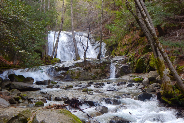
At over 138 feet tall, Boulder Creek Falls was thought to be the tallest waterfall in Whiskeytown National Park until the re-discovery of Whiskeytown Falls in 2004. With three cascades down a canyon covered in moss and ferns, you'll feel like you're in a dream.Driving Time: 15 mins / 9.44 miles from ReddingDistance: 2.25 miles (one way)Difficulty: Moderate
Shasta County
2167
14412 Kennedy Memorial Drive
Whiskeytown, CA 96095
530-246-1225
Brandy Creek Falls is one of the widest waterfalls in Whiskeytown National Park with five cascades that rush over the granite rock of the canyon. Here you will find the unique Indian Rhubarb displaying bright colors in spring and fall. This trail connects to Rich Gulch Trail. This waterfall is accessible by trail. A map of the trail to Brandy Creek Falls is available at the Whiskeytown Visitor Center. Driving Time: 15 mins/9.44 miles from…
Shasta County
5396
Redding, CA 0
This is a great, short, intermediate ride that could be turned into a longer ride by connecting on to the River Trail. Dogs ok on leash. Trail goes downhill toward the River Trail.Distance: 1.23 Miles (From Sacramento River Trail)Difficulty: Intermediate
Shasta County
431
PO Box 80
Castella, CA 96017
530-235-2684
Castle Crags State Park is located in the forest-covered mountains just north of the Sacramento Valley off I-5 near Dunsmuir, CA. The park features soaring spires of ancient granite and includes about two miles of the cool, quick-running upper Sacramento River. Surrounded by primitive back country, the park is six miles south of Dunsmuir and about twenty-five miles north of Lake Shasta on Interstate 5. Elevations range from 2,000 feet along the river to more…
Shasta County
5379
20022 Castle Creek Rd
Castella, CA 96017
With 28 miles of hiking trails, everyone can enjoy a mild stroll or an invigorating adventure. From the Vista Point parking area, a quarter mile accessible trail leads visitors to Vista Point where there are dramatic views of Castle Crags, Mount Shasta, and nearby Grays Rocks. Gentle and shaded, the mile long Root Creek Trail guides hikers along an accessible path to a year round flowing creek.The most popular and challenging route is the Crags…
Shasta County
5389
Chamise Peak Trail
Redding, CA 96003
If you want a 360 degree view of all things Shasta (Shasta Dam, Shasta Lake, Mount Shasta and City of Shasta Lake), look no further. This highest spot atop the mountainous spine separating Keswick Reservoir from the City of Shasta Lake, affords expansive views of the upper Sacramento Valley, the Sacramento River canyon below Shasta Dam and the western mountains. The trail is 2.4 miles, open to both hiking and mountain biking, and dog friendly! Distance:…
Shasta County
2693
I-5 to Shasta Dam
Redding, CA 0
530-244-2100
Chappie-Shasta is a treasure trove of OHV adventures, with over 200 miles of roads and trails running through this 55,000-acre site. It is managed cooperatively by the Bureau of Land Management and the U.S. Forest Service. Uses include shooting, off-highway vehicle use, picnicking, hang gliding, swimming, horseback riding, and mountain bike riding, gold panning and hunting. Parts of this area are used for competitive events, mountain bike races, off-road motorcycle races, archery competition and related…
Shasta County
5394
Redding, CA 0
The Churn Creek trails take walkers through a classic blue oak woodland, with manzanita and gray pine. Sections of the trail meander by Churn Creek where the terrain is riparian with willows, valley oak, western redbud, and cottonwoods.Distance: 4.5 Mile LoopDifficulty: Flat and Rolling
Shasta County
5377
Redding, CA 0
“There’s gold in the hills of California!” Very soon after the discovery of gold in 1848 near Sutter’s Mill, Major Pierson B. Reading discovered gold on Clear Creek. The result was a creek turned upside down. Due to the wildly successful efforts to restore its salmon runs, Clear Creek now hosts increasing numbers of spawning fall Chinook salmon. The best place to see spawning is at the Clear Creek Gorge Overlook. If it is not…
Shasta County
5397
Shasta View Drive
Redding, CA 96002
Clover Creek Preserve is tucked in behind a neighborhood in east Redding, and offers paved, flat trails great for walking or cycling. Enjoy the 2 mile loop with your dog, your favorite people, or just the beautiful view of Redding's rolling hills, oaks, and expansive sky. Distance: 2.0 milesDifficulty: Easy
Shasta County
Prev45678Next
Showing results 51 to 60 of 108
Shasta Cascade Wonderland Association
1699 HWY 273, Anderson, CA 96007 | (P) 530-365-7500
Things to Do | Wine & Dine | Events | Planning | Stay | Regions | Partners | Media | About Us | Contact Us
Website Developed by Drozian Webworks